At the Seldin/Haring-Smith Foundation (SHSF), we invest in solutions that expand equitable access to public services and support accountability for abuse of authority. We look for high-risk, high-impact opportunities to change the public conversation around a particular issue – or drive policy change.
With the arrival of “infrastructure year” in 2021, we saw an opportunity to connect a core higher education issue – transit inaccessibility of community colleges – to the administration’s priorities and the national conversation. With this in mind, our team sought to answer the question, do you need to own a car to attend community college?
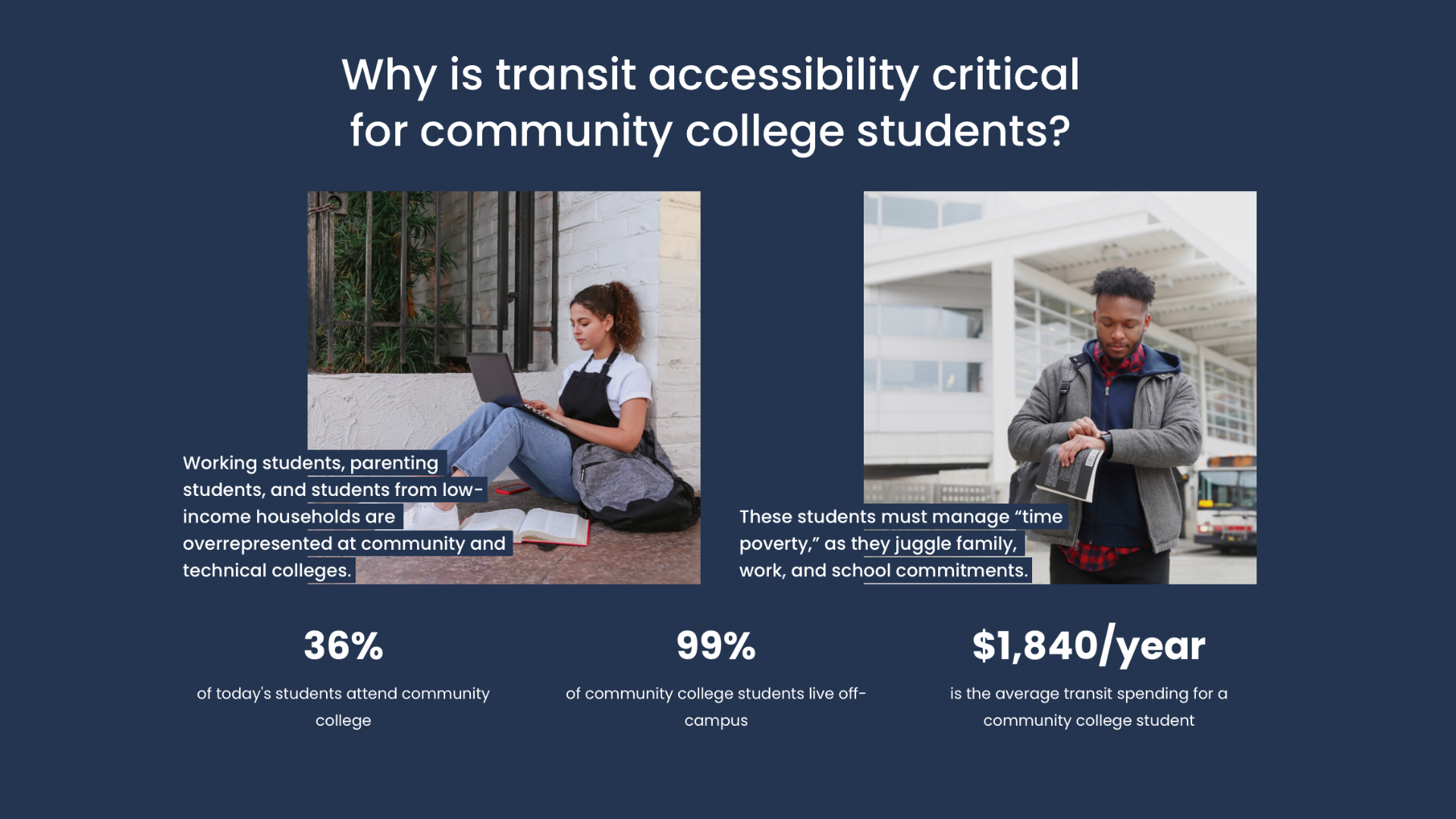
Today, 36% of all college students attend community colleges, and 99% of those students live off-campus and commute to school. Students with children, students with jobs, students of color, and low-income students are all overrepresented at community colleges. Leaders at these schools often say their students are “one flat tire away from dropping out.” Transportation is a very real expense, with students averaging nearly $2000 annually in transportation costs. While insufficient transit access is a known barrier to student success, there was a critical knowledge gap: no one knew which (or how many) community colleges had public transit stops.
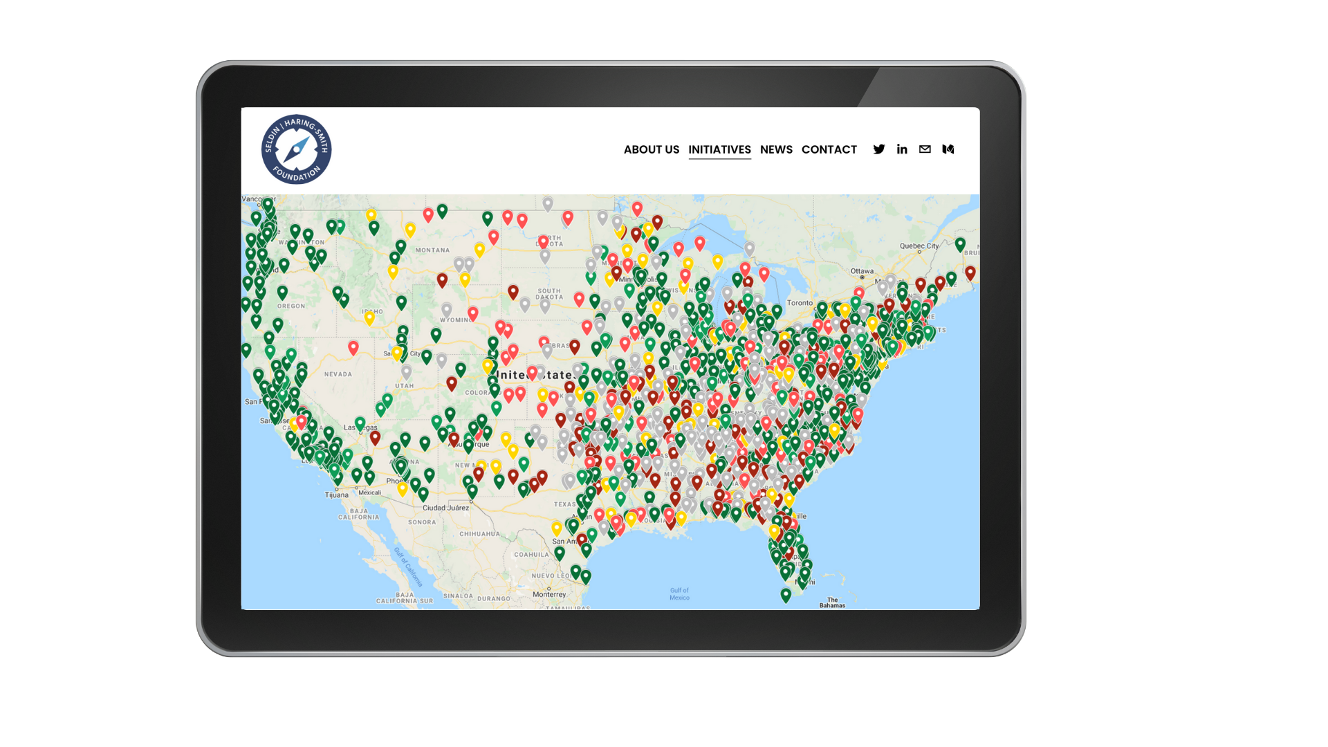
In the Spring of 2021, we published the SHSF Public Transit Map, which assessed public transit accessibility at community colleges across the United States. We found that only 57% of community colleges are transit accessible, but an additional 25% could be made accessible through very low-cost investments in extending existing bus lines. Our data provided the foundation for the bipartisan PATH to College Act, which captures all of the recommendations of the SHSF Public Transit Map research brief. Our report was credited in the Congressional announcements and an endorsement letter that attracted sign-ons from the leading organizations in higher education, including ACCT!
But what about the community colleges beyond the reach of an existing transit system? Our analysis showed that of the 37% of community colleges without a transit stop within walking distance of the primary campus, 18% are located more than 4.5 miles from the nearest transit stop, putting them out of range of the kind of expansion push offered by the PATH to College Act. When a college is not accessible by public transit, students should be able to use federal financial aid for a car purchase. This seems intuitive, but actually it is illegal.
Currently, students are not allowed to purchase a vehicle with federal financial aid funds. While prosecution is unlikely in practice, federal policy is not currently designed to support students who need cars to get to campus. Fortunately, the Biden administration can address this issue without Congress. At present, higher education institutions are prohibited from including the cost of purchasing a vehicle in their cost of attendance (COA). This figure is a college’s “all in” sticker price, and one of the most critical aspects of a student’s college financial aid package. The Department of Education (ED) not only has the authority to allow car purchase as part of students’ COA, it can also flag institutions that do not provide realistic cost estimates for transit and other basic needs.
We expect other policy ideas for improving student outcomes at community colleges to emerge from Phase II of the SHSF Mapping Project, which is well underway. (We’ve been posting regular updates, observations, and some transit humor on our blog every Tuesday.) While useful for painting a national picture of transit accessibility, our first release in 2021 had two meaningful drawbacks that limited its use in setting local policy:
(1) The federal data only contain one address per college, almost always the main campus, with nothing about other campuses and satellite locations.
(2) There are errors of both omission and commission in the Google data. Google Maps doesn’t contain stop info for many (usually but not always smaller) transit agencies, and there are some stops that get flagged which we don’t think of as true public transit (intercity service by a private company, for example, or in one case a Subway restaurant).
To address #1, we had to make the dataset we wanted to see in the world: our new open-source CASL (Campus and Satellite Locations) dataset, which includes all primary, branch, and satellite locations for US public 2-year institutions. We then geocoded the addresses and ran our transit-finder (code in the Phase I report’s appendix) on the resulting coordinates. To address #2, we’re in the process of cleaning the data by hand.
In autumn 2022, SHSF will publish 51 profiles that assess transit access at all primary, branch, and satellite locations for each state’s public 2-year institutions. We look forward to sharing this information with our colleagues at ACCT and policymakers across the country. To stay up-to-date on our progress, follow us on Twitter or Medium.
Further reading: You can view the SHSF Public Transit Map on our website and read recent news coverage in InsideHigherEd and The Hill. SHSF’s one-pager on the SHSF Public Transit Map is available here.
About the authors: Abigail Seldin, Dr. Matthew Crespi, and Dr. Ellie Bruecker are the co-authors of Waiting for the Bus? Transit Infrastructure at America’s Community and Technical Colleges (2021).
Posted: April 20, 2022